Which Mountain Range Separates Europe From Asia
News Leon
Mar 28, 2025 · 5 min read
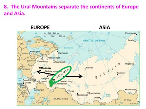
Table of Contents
Which Mountain Range Separates Europe from Asia? The Ural Mountains and the Complexities of Continental Boundaries
The question of which mountain range separates Europe from Asia seems straightforward, but the reality is far more nuanced. While the Ural Mountains are widely considered the primary geographical boundary, the line isn't as clear-cut as a simple mountain range. The division between these two continents is a complex issue involving geology, history, culture, and even political considerations. This article delves into the specifics of the Ural Mountains as a dividing line, explores the ambiguities inherent in continental boundaries, and examines alternative viewpoints and perspectives.
The Ural Mountains: A Defining, Yet Imperfect, Boundary
The Ural Mountains, stretching approximately 1,500 miles (2,400 kilometers) from the Arctic Ocean in the north to the Ural River in the south, are often cited as the primary geographical feature separating Europe and Asia. Their relatively continuous range provides a visually striking and reasonably clear-cut division, making them a convenient landmark for cartographers and geographers for centuries.
Geological Significance of the Ural Mountains
Geologically, the Urals represent a significant boundary. Their formation, during the Paleozoic Era, resulted from the collision of the East European and Siberian cratons (ancient continental plates). This collision created a significant uplift, forming the mountains and contributing to the distinct geological characteristics of Europe and Asia on either side. The Ural Mountains are ancient, significantly eroded, and relatively low compared to other major mountain ranges globally. Their average height is around 3,000 feet (900 meters), with the highest peak, Mount Narodnaya, reaching approximately 6,214 feet (1,894 meters).
Beyond the Mountains: The Ural River and the Caspian Sea
While the Ural Mountains form the backbone of the conventional boundary, the division continues southwards beyond the mountain range's southern extent. The Ural River, flowing south from the mountains towards the Caspian Sea, commonly marks the continuation of the continental boundary. The Caspian Sea itself, the largest inland body of water in the world, further complicates the issue, its northern and western shores commonly considered part of Europe, while the eastern and southern shores are firmly in Asia. This emphasizes that the Europe-Asia boundary is not a simple, linear feature but a complex, evolving delineation.
The Ambiguities of Continental Boundaries
The difficulty in precisely defining the Europe-Asia boundary highlights the inherent ambiguities in assigning rigid boundaries to continents. Continents are not islands with sharply defined coastlines; their borders are often gradual transitions marked by subtle shifts in geology, ecosystems, and human culture. Several factors contribute to the lack of a universally agreed-upon boundary:
Gradual Transitions in Geology and Ecosystems
The transition from European to Asian geological formations isn't abrupt. There's a gradual shift in rock types, soil composition, and the distribution of plant and animal species across the Ural Mountains and beyond. This makes defining a specific point of transition challenging. The ecosystems along the boundary show considerable overlap, blurring the line even further.
Historical and Cultural Influences
Political and historical factors have played a significant role in shaping our perception of the boundary. The historical development of nations and empires has influenced the perceived boundaries, sometimes prioritizing political considerations over purely geographical ones. Cultural aspects, including language and traditions, also have complex and overlapping zones across the presumed boundary. These human factors add further layers of complexity to a simple geographical question.
The Caucasus Mountains and the Black Sea: Further Complications
Adding to the confusion is the complex geography of the Caucasus Mountains and the Black Sea. While the Urals are generally accepted as the primary demarcation in the north, the Caucasus Mountains provide another considerable geographical feature, further complicating the boundary's southern extent. The area around the Caucasus and the Black Sea region possesses diverse geological features and a melting pot of cultures, challenging a straightforward division. This region illustrates how geographical boundaries are seldom straightforward and often intertwined with historical, cultural, and political realities.
Alternative Perspectives and Proposed Boundaries
Given the ambiguities, various alternative proposals for the Europe-Asia boundary exist. Some propose using different rivers or mountain ranges as the dividing line, while others advocate for less geographically defined approaches:
The Volga River Proposal
Some geographers have suggested using the Volga River as a more appropriate marker for the boundary, citing its substantial length and its role as a significant historical and cultural landmark. This alternative acknowledges the complexities and suggests a different approach based on cultural and historical factors instead of solely relying on geological features.
Embracing a Fuzzy Boundary
A more contemporary view acknowledges the lack of a clearly defined boundary. This perspective proposes embracing the gradual transition zone as a feature itself, rather than trying to force a precise, artificial demarcation. This approach recognizes the fluid nature of continental boundaries and the interplay between geological, ecological, and cultural aspects.
Conclusion: The Ongoing Debate of the Europe-Asia Divide
The question of which mountain range separates Europe from Asia is ultimately more complex than a simple answer can convey. While the Ural Mountains provide a convenient and commonly accepted geographical reference, the reality is that the boundary is a nuanced and evolving concept. The gradual transitions in geology, ecosystems, and the overlay of historical and cultural influences make defining a precise line exceedingly difficult. The various alternative proposals and the growing acceptance of a "fuzzy" boundary underscore the ongoing debate surrounding this seemingly straightforward question. The importance lies not in finding a definitive answer but in understanding the complexities involved in delineating continental boundaries and appreciating the interconnectedness of geographical, historical, and cultural factors. The Europe-Asia boundary serves as a valuable case study in understanding the limitations of simple geographical delineations and the need for more nuanced approaches to understanding continental boundaries.
Latest Posts
Latest Posts
-
Passwords Passphrases And Pins Are Examples Of Which Security Term
Mar 31, 2025
-
Both Glucose And Fructose Are
Mar 31, 2025
-
A Perfectly Elastic Demand Curve Implies That The Firm
Mar 31, 2025
-
Which Of The Following Are Complementary Bases In Dna
Mar 31, 2025
-
Classify The Following As A Homogeneous Or A Heterogeneous Mixture
Mar 31, 2025
Related Post
Thank you for visiting our website which covers about Which Mountain Range Separates Europe From Asia . We hope the information provided has been useful to you. Feel free to contact us if you have any questions or need further assistance. See you next time and don't miss to bookmark.
